We’ve reported it before, but it bears repeating, and it looks like SayAnythingBlog is doing their due diligence as well when it comes to the issue of the Dakota Access Pipeline in Morton County.
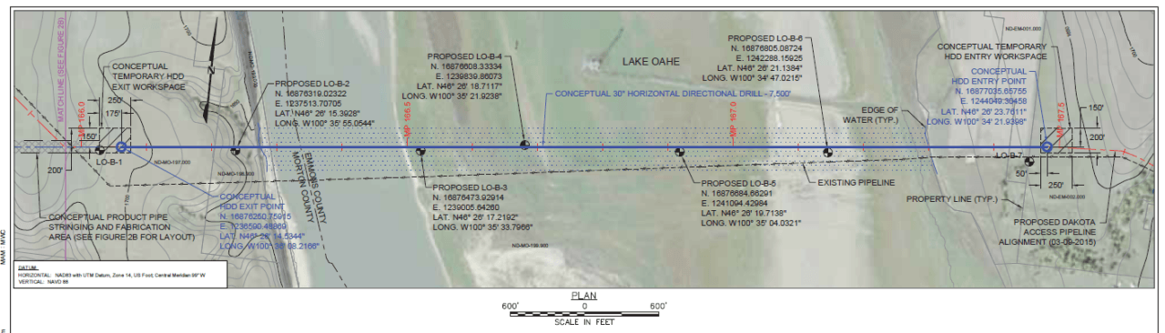
In the 1,206 page Mitigated Finding of No Significant Impact report related to the Dakota Access Pipeline filed by the U.S. Army Corps of Engineers there is a graphic (page. 1008) that clearly shows the Northern Border Pipeline, built in 1982, crossing the Missouri at the location where the Dakota Access Pipeline is being routed.
Here’s what’s notable about SayAnythingBlog’s findings:
“What’s interesting is that the Northern Border line doesn’t seem to have prompted any protests or complaints from the Standing Rock tribe according to the Federal Energy Regulatory Commission’s Environmental Impact Statement for the pipeline:
You’ll note that the Three Affiliated Tribes of the Fort Berthold Reservation expressed some concerns about possible issues with the Northern Border route, but not Standing Rock.
Today the Standing Rock Sioux Tribe has claimed that the Dakota Access Pipeline will destroy significant cultural artifacts along its route, but made no such claims about the Northern Border line.”
Despite the fact the pipeline crosses the exact same private land that the Dakota Access Pipeline crossed, there were only concerns expressed about cultural sites at Compressor Stations 5 and 7 on the Northern Border Pipeline by the Three Affiliated Tribes. The Standing Rock Sioux Tribe did not make any claims that Northern Border would destroy significant cultural artifacts along the route.
Because the Dakota Access Pipeline runs the same length of route for approximately 40 miles, how could cultural artifacts be present when the land has now been surveyed for two separate projects, once for Northern Border and again for Dakota Access?